|
by Jamie McCaughey and Ken Macpherson
Singapore lies about five hundred kilometres from one of the world's most dangerous earthquake zones. How would Singapore be affected by an earthquake there? An Earth Observatory of Singapore study will help to find the answer.
 ingapore sits in the middle of one of the most geologically active regions in the world. Subduction zones, which give rise to volcanoes, great earthquakes and tsunamis, trace an arc around Singapore from the Andaman Islands, through western Sumatra and Java to New Guinea. From Singapore, these hazards seem to be at arm's length. Yet Singapore has experienced some shaking (also called tremors) from nearby earthquakes in the past, felt particularly on the upper floors of some buildings. How might Singapore be affected by nearby earthquakes that we expect to occur sometime in the future? Dr. Ken Macpherson of the Earth Observatory of Singapore (EOS), along with Assistant Professor Goh Siang Huat, jointly of EOS and the National University of Singapore (NUS), is currently working on a project that will help to answer this critical question. ingapore sits in the middle of one of the most geologically active regions in the world. Subduction zones, which give rise to volcanoes, great earthquakes and tsunamis, trace an arc around Singapore from the Andaman Islands, through western Sumatra and Java to New Guinea. From Singapore, these hazards seem to be at arm's length. Yet Singapore has experienced some shaking (also called tremors) from nearby earthquakes in the past, felt particularly on the upper floors of some buildings. How might Singapore be affected by nearby earthquakes that we expect to occur sometime in the future? Dr. Ken Macpherson of the Earth Observatory of Singapore (EOS), along with Assistant Professor Goh Siang Huat, jointly of EOS and the National University of Singapore (NUS), is currently working on a project that will help to answer this critical question.
Probing deep into the Earth
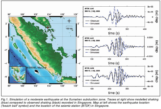
If we want to know how much shaking from an earthquake to expect at any particular place on Earth, we need to know not only the size and location of the earthquake source, but also SFig.1. Simulation of a moderate earthquake at the Sumatran subduction zone. Traces at right show modelled shaking (blue) compared to observed shaking (black) recorded in Singapore. Map at left shows the earthquake location ("beach ball" symbol) and the location of the seismic station (BTDF) in Singapore.the particular structure of the Earth in between. This is a bit like the way that our surroundings affect sound waves. Imagine ten people having a conversation in a comfortable living room with lots of furniture, carpets, and curtains. Then imagine those same ten people having the same conversation, but instead in a very empty room with lots of bare tile and glass. The sound would be much louder, sharper, and more harsh. Earthquake waves are subject to the same kinds of effects - different earth materials and structures can either dampen or amplify earthquake waves.
 Much as a sound engineer must study how sound waves travel through the concert hall, seismologists study how earthquake waves travel through the Earth. The one big difference is that a sound engineer can adjust the loudspeakers to compensate for any effects of the concert hall itself. Seismologists, on the other hand, can do nothing to "adjust" the earthquake source, much as we all may wish that they could; instead, they are only able to describe how severe the ground shaking will be. Much as a sound engineer must study how sound waves travel through the concert hall, seismologists study how earthquake waves travel through the Earth. The one big difference is that a sound engineer can adjust the loudspeakers to compensate for any effects of the concert hall itself. Seismologists, on the other hand, can do nothing to "adjust" the earthquake source, much as we all may wish that they could; instead, they are only able to describe how severe the ground shaking will be.
EOS Research Fellow Dr. Kenneth Macpherson is one such seismologist, studying how earthquake waves travel through Sumatra in order to know how much shaking Singapore might experience when future earthquakes occur. The first step was to build a picture of the structure of the Earth beneath Sumatra. But how can we learn about things that we cannot see directly? Clearly, it is not possible to dig through the crust of the Earth to take a firsthand look.
Fortunately for studies like this, the Earth comes with its own built-in probe: Earthquakes. There are thousands of earthquakes each day that are too small for us to feel but big enough for sensitive seismometers to record. In addition, larger earthquakes that occur far away send earthquake waves all across and through the Earth; these, likewise, are generally too small for us to feel but big enough to record. All a seismologist need do is tune in and listen. By using seismometers to "listen" to the frequent small vibrations of the Earth, seismologists can piece together the structure of the crust of the Earth. Much like a rock on a riverbed causes ripples on the river surface, or a reef on the seafloor causes waves to grow taller and break, the deeper structures of the Earth causes telltale patterns in the earthquake waves that reach the surface of the Earth.
The crust of the Earth appears as a smooth, even layer in textbooks, looking something like a layer cake. But actually it is much more of a jumble, more like lasagne or tempeh. Beneath the surface of the Earth lie the gifts of hundreds of millions of years of plate motions - hidden treasures such as great fault lines, ancient basins that have long ago been filled with sediment, crystalline cores of ancient mountain ranges, and fractured and folded ancient seafloor sediments. As earthquake waves travel through this jumble, the waves can bend, slow down, speed up, and reflect; understanding exactly how and where this happens is critical for understanding how much shaking from earthquakes to expect at each spot on the surface of the Earth. Sediment-filled basins surrounded by mountains are particularly likely to amplify earthquake waves; this is one reason that the 2008 magnitude 7.9 Sichuan earthquake caused so much destruction and so many deaths.
A model for earthquake waves
Once the earth structure is known, the next step is to develop a computer model of how earthquake waves will travel through that earth structure. Although realistic models are very complex, the idea behind them is quite simple: Combine an understanding of physical processes with various scenarios to see the results. For example, we know that if a car is travelling at a constant speed of 100 km/hr, it will be 200 km from its starting point two hours after it started. If the car was travelling at a different speed, we would get a different answer. But this model is too simple to be realistic; it does not take into account complications such as changes in speed limits, traffic, red lights, and weather. If we wanted to come up with numbers to actually predict how significant each of these factors might be, we would need to dive headfirst into detailed traffic data and complex math and statistics. Thus, as models become more realistic, they tend to become more complex.
 Although rock seems quite solid and brittle, earthquake waves can momentarily cause rock to behave more like an elastic band, moving and then quickly snapping back to its original shape and position. Imagine a crowd "Wave" (or "Kallang wave" for our Singaporean readers) that sometimes happens in a sports stadium. Each individual person stands up and sits down quickly at the moment when the "Wave" passes them; although the wave itself travels across the entire stadium, each person stays at their own seat. Although rock seems quite solid and brittle, earthquake waves can momentarily cause rock to behave more like an elastic band, moving and then quickly snapping back to its original shape and position. Imagine a crowd "Wave" (or "Kallang wave" for our Singaporean readers) that sometimes happens in a sports stadium. Each individual person stands up and sits down quickly at the moment when the "Wave" passes them; although the wave itself travels across the entire stadium, each person stays at their own seat.
The ideal way to model earthquake waves is to use wave equations, a particular application of advanced calculus. These equations take into account the elastic behaviour of the rock and describe how earthquake waves travel through that material. Wave equations work well if the material is the same throughout; however, they cannot provide an exact solution for real earth materials that are often highly variable from place to place.
Dr. Macpherson tackles this real-world challenge by breaking the problem up into little pieces. Instead of a single wave equation to describe the entire path of the earthquake wave, he breaks the region into a fine 3-D grid and then uses computing power to solve separate equations for each individual cube in that 3-D grid. As a simulated earthquake wave travels through this model grid, the solution that is output from one grid cube is the input for the calculations in the next grid cube.
To get a realistic model, Dr. Macpherson uses a half-kilometre grid spacing, which amounts to millions of individual grid cubes. Such a fine grid is needed to realistically describe higher-frequency earthquake waves, up to 1 wave cycle per second (1 Hertz). Then the computer has to do some heavy lifting - for each of the millions of grid cubes, nine separate equations are solved for each 0.02 second interval. These calculations are then repeated for each 0.02-second time interval for a total model time of five minutes. These calculations would take years on a typical laptop and millions of years to do by hand! Thus, Dr. Macpherson runs this model on supercomputing facilities at NUS.
Let's try a few earthquakes!
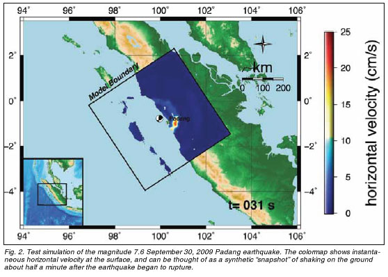
Once the earth structure and the way that earthquake waves will travel through it are known, it is time to try out a few model earthquakes. But again we run into a problem with scale; while a chemist can combine fluids in a lab and observe the result, seismologists are not able to (nor would they want to) create large earthquakes for their research. Hence, they turn to computer models. Using computers, seismologists can "create" any model earthquake that they like - any magnitude, location, depth, and style of fault slip - and then see how much shaking it would cause at each place (Figs. 1 and 2).
But for earthquake modelling to be useful, it is best to input the kinds of earthquakes that we realistically expect to occur. What kinds of earthquakes are likely to occur in western Sumatra? To answer this question, EOS and other earth scientists have used a combination of GPS measurements of deforming plates, historical earthquake measurements from GPS and seismometers, and records of ancient earthquakes preserved in the growth patterns of corals that sit atop the Sumatran subduction zone. The results indicate that a large (roughly magnitude 8.8) earthquake is likely sometime in the coming decades on the segment of the Sumatran subduction zone near the Mentawai Islands and Padang. This happens to be the closest segment of the Sumatran subduction zone to Singapore, at about 500 km distance.
Bringing it home to Singapore
As with many models of earth systems, this project is ongoing. Currently, the project is limited by the amount of available seismic data; this in turn limits the accuracy of the picture of the earth structure in and around Sumatra. Securing access to additional seismic data sources would significantly improve the picture of the earth structure in and around Sumatra, and thus significantly improve the accuracy of the model output from various earthquake scenarios.
Although Singapore is not considered to have high earthquake risk, there remain many unanswered questions about how Singaporean buildings would be affected by a great earthquake in West Sumatra. This study alone will not answer all those questions - but by providing better estimates of the potential shaking at each site, it will help engineers throughout the region to evaluate building codes and the earthquake resistance of existing buildings. This study will also provide valuable inputs to more detailed studies of the effect of earth materials on ground shaking in Singapore undertaken by EOS Assistant Professor Kusno Megawati, as well as to engineering studies of the earthquake resistance of Singaporean buildings.
 Click here to download the full issue for USD 6.50 Click here to download the full issue for USD 6.50
|