|
by Dr Liew Soo Chin
 emember the big Indonesian fires when Singapore and its neighbours found themselves enshrouded in heavy smoke? emember the big Indonesian fires when Singapore and its neighbours found themselves enshrouded in heavy smoke?
Fire has been the traditional tool for clearing land for shifting populations cultivating small-scale farms in the region. However, this pattern is increasingly giving way to modern large-scale conversion of forests into plantations/agricultural land, usually by means of burning. In times of drought, especially during periods when El Niño strikes, the fires get out of control, spreading clouds of smoke throughout the region. El Niño a disruption of the ocean-atmosphere system in the tropics, has become synonymous globally with warm climate.
In response to the haze episode in 1997, the ASEAN Environment Ministers agreed on a Regional Haze Action Plan. This plan sets out cooperative measures among member countries to address the problem of smoky haze in the region arising from land and forest fires. Under the plan, Singapore has assumed the responsibility of coordinating the regional land and forest fire monitoring mechanisms.
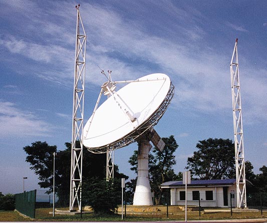
To that end, the Singapore Ministry of the Environment (ENV) commissioned the National University of Singapore's Centre for Remote Imaging, Sensing, and Processing (CRISP) to perform daily fire-monitoring operations using high-resolution satellite imagery. When CRISP first commenced operation in 1995, it was equipped with a ground receiving station. Today, the centre receives data from various remote-sensing satellites. It carries out its fire-monitoring operation using French SPOT (Satellite pour l'Observation de la Terre) satellites, sophisticated remote-sensing orbiters capable of resolving details as fine as 10m at ground level.
Using the high-resolution imagery from SPOT satellites, the centre can determine with precision the exact locations of fires, sizes of areas affected, and types of land on fire. It is possible to tell whether the fires are in forests, peat swamps, or plantations, and whether they are associated with such activities as clearing of agricultural land or timber logging.
The information on the fire situation is then disseminated to the relevant authorities in the affected countries. Recently several SPOT satellite images showing fires in oil palm plantations together with the details of the fire locations were delivered to the forestry law enforcement authority in Indonesia as evidence in order to prosecute the liable parties.
Another class of satellite commonly used in fire monitoring includes the American NOAA (National Oceanographic and Atmospheric Administration) satellite. The sensors on these satellites can detect hot spots that indicate fires. Data can be received using a relatively inexpensive setup, and many centres in the region have the capability to access NOAA data.
However, NOAA images have a resolution of 1km, too coarse for pinpointing the exact locations of fires. The whole 1km-by-1km pixel (the smallest image-forming unit of a video display) will be labelled a hot spot even if only a small fire exists somewhere inside the 1km² area.
Scientists at CRISP have devised a novel way of locating fires accurately, relying on available satellite images. Using the distribution of hot spots derived from NOAA images as a guide, CRISP can programme the SPOT satellites to get zoomed-in views of the hot areas. This synergistic use of both low- and high-resolution satellite imaging increases the success rate of fire-detection in the region.
Several other innovations implemented by CRISP enable operators to carry out fire monitoring efficiently. The data-receiving systems are modified such that high-resolution images can be processed and made available within 10 minutes of each satellite pass, making it now possible to perform the fire-monitoring operation in almost real-time. Visualisation software has been developed not only to display the resultant huge amount of data systematically, but also to extract the fire location automatically once a fire has been detected.
Oil over Troubled Waters
Oil pollution in the sea is another major environmental concern that affects many countries in Southeast Asia. Space-borne synthetic aperture radar (SAR) imagery has become an important tool in monitoring marine oil spills because of its wide coverage in all weather conditions, day and night. In SAR images, smooth sea surface appears dark whereas the brightness increases as the sea surface becomes rougher. Oil slicks generally appear dark and can be picked out against a brighter background in SAR images.
Using satellite SAR images, CRISP has successfully enabled the Maritime and Port Authority (MPA) of Singapore to get a conviction against a culprit responsible for an incident of oil pollution. In August 1996, an oil tanker dumped a large quantity of oil into the sea off the west coast of Singapore. CRISP captured a SAR image acquired by the European Remote Sensing (ERS) Satellite, clearly showing a ship trailing a 5km long plume.
After a careful analysis of this image and other data such as oil samples collected from ships in the area and from the sea surface, the MPA could unambiguously name the polluting ship. The ship owner, agent, and officers pleaded guilty to the offence and were fined S$1.25 million. This case gained international notice as it was the first time the prosecution had successfully used a satellite image as court evidence.
More recently, on 3 October 2000, a Panama-registered tanker ran aground in the shipping lane between Indonesia and Singapore, spilling at least 7,000 tonnes of crude oil into the sea. The incident occurred in Indonesian waters, about 8km south of Singapore. It was reported that the salvage operator had put an oil boom (a floating device used to contain spills) around the vessel to keep the leak from spreading. Despite the effort to contain the spill, the oil escaped the boom and was seen spreading towards Sumatra and Singapore. CRISP assisted MPA in monitoring the oil slicks by using satellite images. The spread of the oil was captured in a sequence of SPOT and ERS satellite images from 8-11 October.
CRISP has also compiled statistics on ocean pollution from its archive of ERS images. It has compiled, using more than 5,500 scenes of ERS images in its archive, a map showing the distribution of oil slicks in regional waters. All major shipping routes suffer from varying degrees of pollution. The most heavily affected area is the South China Sea off southeast Vietnam, the main intersection of shipping routes. In this zone, more than 25 oil slicks can be expected in a typical ERS image scene covering an area of 100km by 100km.
Global Participation
Scientists at CRISP participate as principal investigators in scientific projects of NASA (National Aeronautics and Space Agency), NASDA (National Space Development Agency of Japan), and ESA (European Space Agency). CRISP also uses satellite data to conduct red tide monitoring in regional waters in collaboration with the Department of Biological Sciences, the Department of Civil Engineering, and the Tropical Marine Science Institute of NUS, together with the Marine Science Institute of the University of Philippines. It has another joint research project with SPOT Asia, developing remote-sensing techniques for red tide monitoring.
Satellite remote-sensing technology evolves with the development and launch of new satellite sensors with more spectral bands and better spatial resolution. With the availability of more spectral bands, identification of land-cover types and conditions can be made more precise. An improvement in spatial resolution enables clearer view of objects and features on the ground to be obtained. For instance, with the recently available 1m resolution imagery, one can even discern individual trees.
CRISP's researchers continue to explore the potential of the new technology in, among other applications, environmental monitoring.
Satellite imagery provides a good overview of the earth's surface. Owing to the predictable and repetitive orbits of the satellites, frequent and regular observation of a given location has become possible. These eyes in the sky serve as important watchdogs that help in monitoring the health of our terrestrial and marine environments.
For more information contact Dr Liew Soo Chin, a Senior Research Scientist and Head of Research at the Centre for Remote Imaging, Sensing, and Processing at: liew_soo_chin@nus.edu.sg. Alternatively, check out: www.crisp.nus.edu.sg.
|